INTRODUCTION
City Heights is a public housing complex that was built in 1953 to address the need for low-income housing in the area. Today, the apartments are in a state of disrepair and the site remains disconnected from the community as discussed below. In October 2021, after two years of discussion, federal housing officials approved plans to gradually shut down the complex, in the next three years.[1] [2] [3]

History Part 1 – Development of Public Housing
Many low-income public apartment complexes were built in the middle of the 20th century. Regional examples include housing in the West End of Cincinnati, Newport’s Two Rivers area, Covington’s East Side, and various scattered areas of the urban core.
While new public housing at the time was intended to address crowded and unsanitary conditions of old 19th century urban tenements and cheaply built houses, there also were components of racism and classism in these housing projects. The approach was to remove low-income households and people of color from centrally located areas. Unfortunately, the mind set seemed to be “out of sight, out of mind”.
Other housing project developments exist in the area near City Heights, including Latonia Terrace, the Two Rivers Apartments, Millvale, and Stanley Row Towers, which, though not necessarily ideal in form and layout, are all more integrated into the surrounding neighborhoods and city. Additionally, similarly disconnected public housing projects exist at English Woods, Sutter View, the Villages at Roll Hill, and Winton Hills.
Though the public housing built in the 20th century addressed the problems of physical conditions, it did not alleviate the socioeconomic factors that led to these problems in the first place, and in some cases, made the problems worse through physical isolation.
History Part 2 – Impact on Connectivity
The replacement of older neighborhoods in the mid-20th century created a massive disruption to existing social structures and networks, especially for low-income minorities. These projects isolated low-income communities from the rest of the city, rather than integrate them into it, creating a myriad of issues. Among these issues were the remote location of several housing projects in limited-access regions near the urban core leading to less connection to economic opportunity. It also led to social isolation, limiting exposure to public schools, parks, markets, and events of the local community and surrounding communities.
Social and economic isolation was intensified by lack of access to transportation. Around the time Americans were developing the automobile culture, automobiles were becoming less affordable to those in the lower economic class. The remoteness of many of these housing communities meant owning an automobile was critical for access to jobs, education, healthcare, and support systems. In addition, systems developed for public transit are often not the most convenient at these locations. Whereas the cheapest options, walking and cycling, are the most financially achievable means, they are impractical to get to most places to fulfill basic needs as well as being inconsistent - not developed completely from one point to the next - in their development. Even today walking paths and biking trails are most frequently developed in more affluent areas as an amenity, not for public necessity.
History Part 3 – City Heights Problems
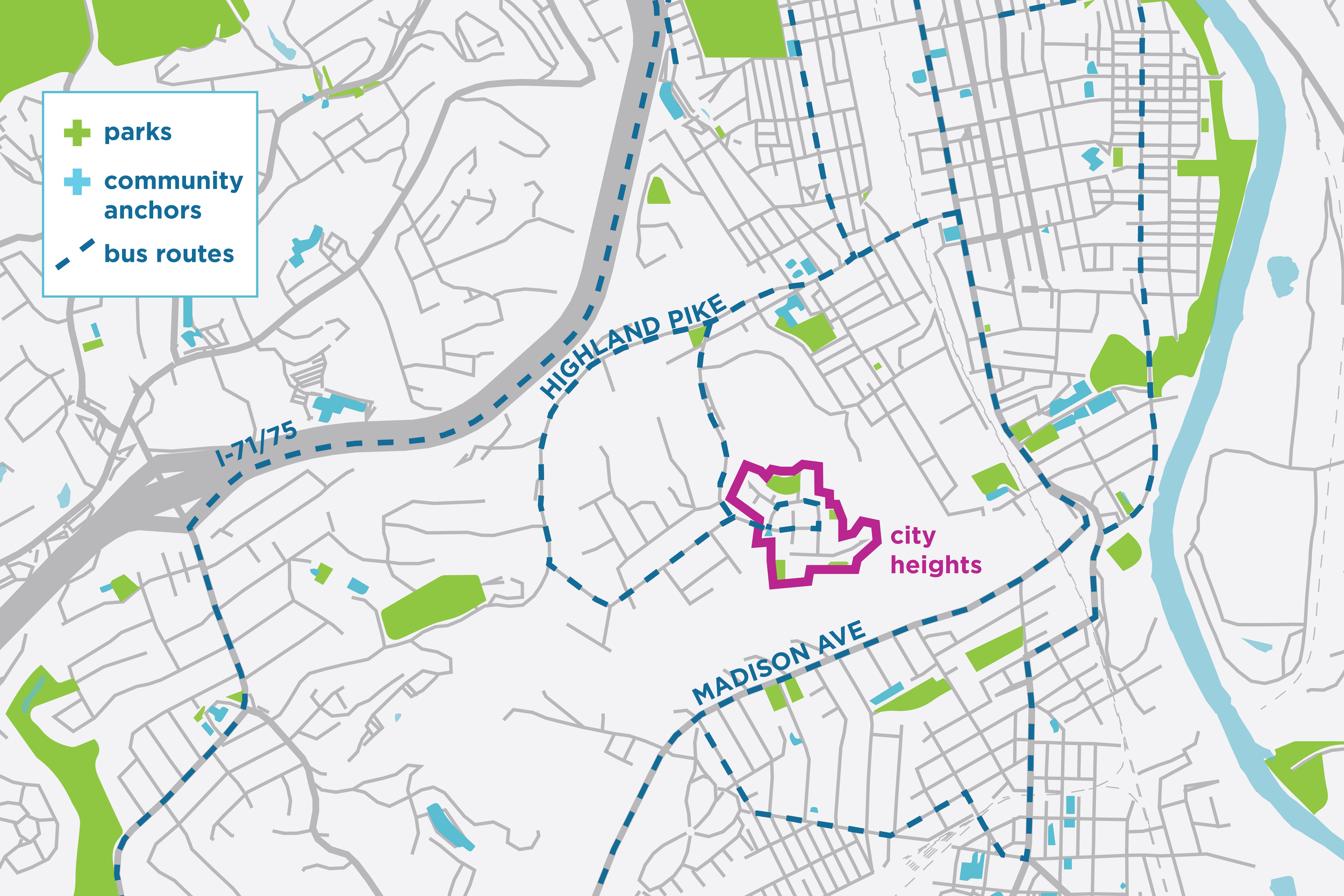
Problems with City Heights are well documented.[4] These issues are a result of many of the previously presented thoughts. Due to its hilltop location, the site is very cut off from surrounding neighborhoods in Covington and Latonia. The closest building in City Heights sits physically 650 feet from the nearest building of the Latonia Terrace Public Housing Complex, but it takes 2.5 miles to get there due to the winding streets and paths formed to access the hill.
There is only one road in and out, Benton Road – which also forms a major route up the hill to Monte Casino from Highland Pike and Covington’s Peaselburg neighborhood. There are no other routes in and out without cutting through the surrounding forest, where there are no developed trails or public stairs, and likely would not be legal due to trespassing on undeveloped or unmarked private property. Primary transportation methods are the automobile, and the only TANK [5] bus that goes to the hilltop is Bus Route 5, but it does not connect directly to needed services like groceries and schools; a second or sometimes a third bus connection is needed to get to these places.
There is a small grocery store in the site, Hilltop Market, and the Saint Augustine Parish provides a Food Distribution Center from one of the City Heights buildings. The nearest grocery store, Kroger, is down the hill in Covington accessed by taking the Route 5 bus, plus a, 8 block walk through 19th street and Madison Ave (walking through 15th street could be closer, but there are no sidewalks on the overpass over the train tracks). The Latonia 9th District Elementary Public school is also nearby, but with the same access issues as the grocery store. See the map below for the nearest schools and locations of public buildings in relation to City Heights.
Envisioning the Future of City Heights and its Community
How could City Heights be re-imagined in a way that provided affordability AND livability?
Ultimately, dispersion of affordable housing throughout the community and region is the most sustainable option. Scattered site smaller-scale low-income reserved housing at the same rental price – could be placed as infill at strategic locations around the urban core, would provide affordable housing and better mix residents into the surrounding social and economic fabric. Locations – underutilized parcels on streets in places like Westside, Downtown Covington, Mutter Gottes, Botany Hills, Latonia, Wallace Woods, Austinburg, Peaselburg, and Mainstrasse Village. Could propose some basic idea of what this could look like.
A similar outcome could be achieved by connecting the hilltop in a better way to the surrounding city through a mixed-use redesign that integrates housing for all classes, services, amenities, and of course, transportation. The idea would be to create a “hilltop village” with medium density apartments that is aesthetically pleasing and functional for all its residents and with a stronger and reciprocal relationship to the communities that surround it. Low-density town-homes flowing down the hillside would integrate Latonia Terrace with City Heights, Peaselburg, Monte Casino.
More vehicular and public transportation routes up the hill would need to be added to connect to Madison at Latonia Terrace, Warren Street, and Center Street. New walking and biking paths that can be used not only to connect to the surrounding neighborhoods, but also as amenities would add value to the site. Adding community amenities within this specific hilltop geography like small parks, picnic areas, cafes, a healthcare and fitness center, small retail stores, access to public offices and banking would activate the site and make it a destination.
Tune in next time! We’re going to draw something.